


Introduction
Flooding during the monsoon season causes significant damage to the people, economy, and ecological balance in Nepal. The flooding situation is worsened by several factors, including climate change, deforestation, rapid and unplanned urbanization, outdated infrastructure, encroachment on riverbanks, settlements in low-lying floodplain areas, a lack of drainage systems and detention basins, and, most importantly, insufficient preparedness to handle the resulting disasters.


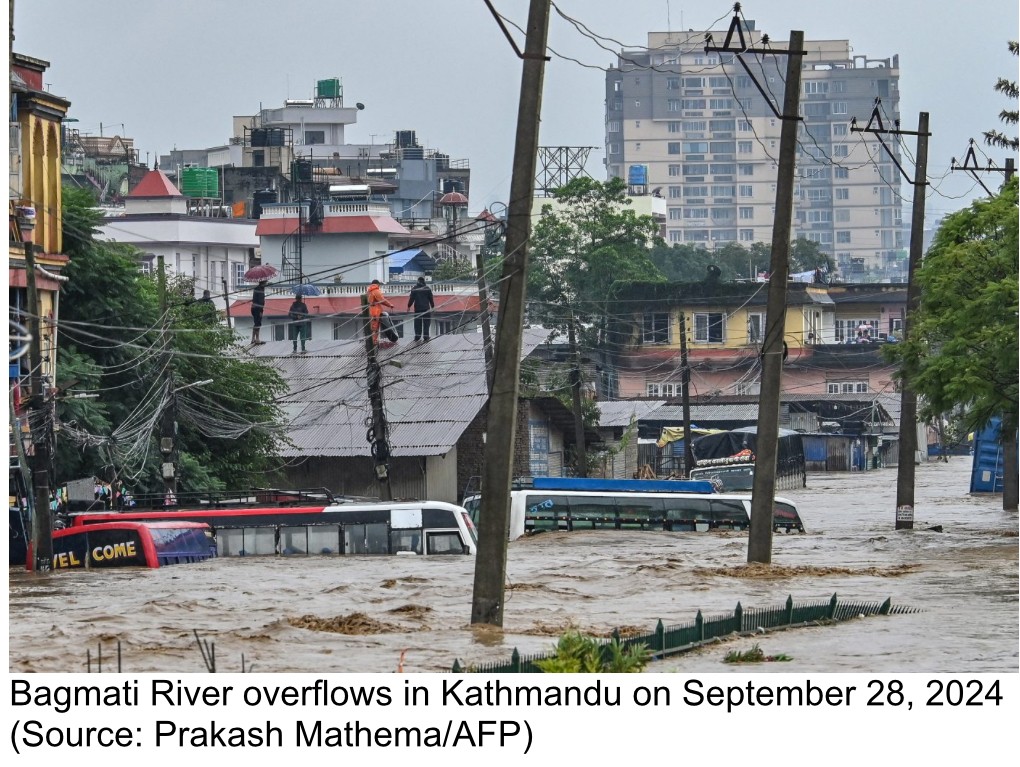
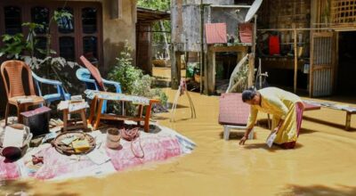
From September 26 to 28, 2024, flooding resulted in 239 fatalities and 178 injuries, according to the Ministry of Home Affairs. The floods also caused extensive damage to buildings, agricultural resources, and livestock. Many infrastructures, including bridges, telecommunication stations, water pipes, and hydropower plants, were severely affected. Some regions experienced the highest levels of precipitation in over 50 years, with the Kathmandu Valley receiving up to 322.2 millimeters (12.69 inches) of rain, leading to widespread flooding.


This situation should serve as a wake-up call for government authorities and non-governmental organizations involved in flood management in Nepal. Implementing pre-flood preparedness and preventative measures can help minimize loss of life and damage to property, including residential and commercial buildings as well as infrastructure. Such measures also enhance response, recovery, and restoration processes.
Types of Flooding in Nepal
Flooding in Nepal can be categorized into four types: Glacial Lake Outburst Flood (GLOF) in the Higher Himalayas, Mountainous Region Flooding, Urban Flooding, and Tarai/Southern Plain Flooding.
Glacial Lake Outburst Floods (GLOF’s):
A Glacial Lake Outburst Flood (GLOF) is a sudden release of water from a glacial lake, typically caused by the collapse of a natural dam made of moraines that hold the lake in place. Moraines are accumulations of rocks and sediments that have been transported and deposited by glaciers. These lakes form as glaciers melt, and they can become unstable if the glacier retreats or if excessive water builds up behind the ice or moraine dam. There are over two thousand glacial lakes in Nepal. When the dam fails, water from the glacial lakes floods the downstream areas, leading to significant damage to homes, infrastructure, ecosystems, hydroelectric power plants, and communities living in the floodplain.
On August 16, 2024, a glacial lake in the Khumbu Region of Eastern Nepal overflowed, flooding the village of Thame in the Solukhumbu district, which is situated at an elevation of 12,467 feet. The flood destroyed dozens of houses, hotels, a school, and a health clinic, displacing 60 people in the process.
Mountainous Region Floods:
Flooding in mountainous areas can result from both natural and human-induced factors. Floods can sweep away homes, roads, and bridges in these regions. Intense and prolonged rainfall on steep slopes leads to rapid runoff, causing rivers and streams to overflow, which can result in flash floods in valleys and low-lying areas. Heavy rain in mountainous terrains can also trigger landslides and create temporary dams. If these dams break, they can release massive amounts of water, causing flooding in downstream areas.
Deforestation and the removal of vegetation in mountainous regions lead to soil erosion, reducing the land’s ability to hold and absorb rainwater. This increases runoff and heightens the risk of flooding and mudslides.
Furthermore, unregulated construction on steep slopes, poorly planned roads, and mining operations can destabilize the land, increasing the likelihood of floods and landslides.
Urban Floods:
Rapid and unplanned urbanization often leads to an increase in impermeable surfaces, such as concrete and asphalt, which prevent water from being absorbed into the ground and elevate the risk of flooding. Additionally, urban areas frequently lack adequate drainage systems and detention basins to effectively manage stormwater runoff. Flooding in these urban environments is likely to become more frequent and intense due to climate change, which alters precipitation patterns and contributes to extreme weather events. A recent example of urban flooding occurred in September 2024, when the Kathmandu Valley and surrounding areas experienced severe flooding from heavy and continuous rainfall. The Bagmati River and its tributaries rose significantly above safe levels, causing widespread inundation and resulting in the loss of both lives and property.
Southern Plain (Tarai Region) Floods:
The Tarai region in Nepal experiences heavy monsoon rains, which can lead to intense rainfall over short periods. This excessive rainfall often overwhelms river systems and causes flash floods. The area is crisscrossed by numerous rivers and streams that originate in the Himalayas. These rivers carry runoff from heavy rainfall and snowmelt, leading to overflowing banks. Additionally, they transport large amounts of sediment from the erosion of the mountains, which can clog their flow paths and contribute to flooding during heavy rain.
In recent decades, significant deforestation and the removal of vegetation in the Tarai region have reduced the land’s ability to absorb water. This results in increased surface runoff and a higher likelihood of flooding during heavy rains. When flood protection infrastructure, such as dikes, embankments, and levees, fail due to poor maintenance, floodwater can spread across the region, causing inundation. Together, these factors make the Tarai region highly vulnerable to flooding.
Strategies and Initiatives for Developing Flood Resilience in Nepal
Considering the vulnerability to flooding during the monsoon season, the four major rivers in Nepal—Koshi, Gandaki, Karnali, and Mahakali—and their numerous tributaries often overflow, causing significant damage. To mitigate the impact of flooding, Nepal can adopt several strategies and initiatives aimed at increasing preparedness. These initiatives will enhance the capacity of communities to withstand and recover from flood events.
The essential components for developing flood resilience in Nepal are outlined below:
Community Engagement
- Raise awareness among local communities about flood risks, emergency preparedness, and response strategies. Train residents in immediate actions to take when the flood warning is issued.
- Assess vulnerabilities and specific needs of local communities concerning flood risks, and plan disaster risk reduction accordingly.
- Train community members, local authorities, and volunteers in flood response and resilience strategies to build disaster management capacity.
- Organize “Flood Safety Day” annually to educate local communities about flooding risks and effective preparation methods to minimize their impact on lives and livelihoods.
- Incorporate courses on disaster education into school and college curricula.
Early Flood Warning
- Develop accurate flood forecasting systems and issue early warnings to assist communities in their preparedness, enabling them to exercise precautions and evacuate if necessary.
- Build effective communication networks to relay early warning messages to remote and vulnerable communities in real-time.
Resilient Infrastructure and Housing
- Improve the maintenance of flood protection infrastructure such as levees, dams, and embankments.
- Promote the construction of flood resilient housing on elevated structures using durable and flood-resistant materials.
Drainage Systems and Detention Basins Construction
- Construct and maintain effective drainage systems to prevent urban flooding in towns and cities.
- Build detention basins to store stormwater runoff, reducing flooding risks and utilizing the stored stormwater for irrigation and other purposes during dry seasons.
Reforestation and Watershed Management
- Encourage tree planting, vegetation management, and adopt soil conservation practices to reduce flooding impacts and the risk of landslides.
- Practice sustainable watershed management by preserving the ecosystems of forests, wetlands, and floodplains, which serve as natural barriers against floods.
Climate Chage Adaptation
- Prepare for disaster management strategies to address intense floods and flash floods resulting from unpredictable rainfall patterns and cloudbursts due to climate change.
- Monitor and manage glacial lakes, creating emergency plans for communities downstream to address the risks of Glacial Lake Outburst Floods (GLOF’s) caused by the rapid melting of glaciers due to global warming.
Satellite imagery for Mapping Flood Zones
- Use Satellite Imagery and GIS Technology to map flood-prone areas, and to monitor flood risks over time.
- Map the landscape before and after flooding using Satellite Imagery to identify flood source areas.
- Combine Satellite Imagery with ground-based data to forecast floods.
Riverbank and Floodplain Encroachment Prevention
- Enforce laws and regulations to prevent encroachment on riverbanks and floodplains. Riverbank encroachment occurs when structures such as houses, roads, and industrial facilities are built along riverbanks. This development narrows and alters the river’s natural course, increasing the risk of overflow during heavy rainfall and leading to significant flooding. For instance, the encroachment of the Bagmati riverbanks has worsened flooding in the Kathmandu Valley, as demonstrated by the severe flooding that occurred in September 2024.
- Moreover, encroaching on natural floodplains causes rivers and streams to flow more rapidly and become more concentrated. This results in more intense flooding during heavy rain, causing floodwater to spread over large areas of floodplain settlements.
Flood Risk Management Plans
- Develop national, provincial, and local flood risk management plans incorporating flood resilience into disaster risk reduction and climate change policies.
- Implement flood resilience strategies and foster collaboration between the government, local authorities, and non-governmental organizations (NGO’s) to share resources and technical expertise.
Conclusion
Building a flood-resilient Nepal requires a comprehensive approach that includes community-based initiatives to empower local populations, from villages to cities, through education and training in flood preparedness, response, and disaster management. Efforts should also prioritize the preservation of ecosystems by promoting reforestation and restoring vegetation, developing and maintaining critical infrastructure, and implementing strategies for climate change adaptation. In addition to mitigating the immediate impacts of flooding, these initiatives should focus on enhancing preparedness and ensuring long-term sustainability in light of the increasing risks posed by climate change.
The National Disaster Risk Reduction and Management Authority (NDRRMA) is an agency under the Ministry of Home Affairs of the Government of Nepal, established by the Disaster Risk Reduction and Management Act of 2017. NDRRMA is crucial in enhancing flood preparedness, facilitating effective communication, coordinating responses, and proactively building community resilience. It can achieve these goals by collaborating with local governments, communities, and non-governmental organizations (NGOs), provided it has adequate funding and staffing.


प्रतिक्रिया